Occupation Summary

Geographic Information Systems Technologists and Technicians

O*NET 15-1299.02

Description:

Assist scientists or related professionals in building, maintaining, modifying, or using geographic information systems (GIS) databases. May also perform some custom application development or provide user support.

Annual Wages:
$113,248.00
Employment Rate:
Employment is expected to increase by 28.88%.
Education Level:
Bachelor's Degree. According to O*Net, the majority of people employed in this occupation have this level of education.
Endorsement:
Business and Industry, Science Technology Engineering and Math (STEM)

  1. Produce data layers, maps, tables, or reports, using spatial analysis procedures or Geographic Information Systems (GIS) technology, equipment, or systems.
  2. Design or prepare graphic representations of Geographic Information Systems (GIS) data, using GIS hardware or software applications.
  3. Maintain or modify existing Geographic Information Systems (GIS) databases.
  4. Provide technical expertise in Geographic Information Systems (GIS) technology to clients or users.
  5. Perform computer programming, data analysis, or software development for Geographic Information Systems (GIS) applications, including the maintenance of existing systems or research and development for future enhancements.
  6. Enter data into Geographic Information Systems (GIS) databases, using techniques such as coordinate geometry, keyboard entry of tabular data, manual digitizing of maps, scanning or automatic conversion to vectors, or conversion of other sources of digital data.
  7. Review existing or incoming data for currency, accuracy, usefulness, quality, or completeness of documentation.
  8. Perform geospatial data building, modeling, or analysis, using advanced spatial analysis, data manipulation, or cartography software.
  9. Design or coordinate the development of integrated Geographic Information Systems (GIS) spatial or non-spatial databases.
  10. Perform integrated or computerized Geographic Information Systems (GIS) analyses to address scientific problems.
  11. Select cartographic elements needed for effective presentation of information.
  12. Provide technical support to users or clients regarding the maintenance, development, or operation of Geographic Information Systems (GIS) databases, equipment, or applications.
  13. Collect, compile, or integrate Geographic Information Systems (GIS) data, such as remote sensing or cartographic data for inclusion in map manuscripts.
  14. Interpret aerial or ortho photographs.
  15. Meet with clients to discuss topics such as technical specifications, customized solutions, or operational problems.
  16. Document, design, code, or test Geographic Information Systems (GIS) models, internet mapping solutions, or other applications.
  17. Create, analyze, report, convert, or transfer data, using specialized applications program software.
  18. Confer with users to analyze, configure, or troubleshoot applications.
  19. Design, program, or model Geographic Information Systems (GIS) applications or procedures.
  20. Develop specialized computer software routines, internet-based Geographic Information Systems (GIS) databases, or business applications to customize geographic information.
  21. Make recommendations regarding upgrades, considering implications of new or revised Geographic Information Systems (GIS) software, equipment, or applications.
  22. Assist users in formulating Geographic Information Systems (GIS) requirements or understanding the implications of alternatives.
  23. Create visual representations of geospatial data, using complex procedures such as analytical modeling, three-dimensional renderings, or plot creation.
  24. Transfer or rescale information from original photographs onto maps or other photographs.
  25. Prepare training materials for, or make presentations to, Geographic Information Systems (GIS) users.
  26. Apply three-dimensional (3D) or four-dimensional (4D) technologies to geospatial data to allow for new or different analyses or applications.
  27. Conduct research, data analysis, systems design, or support for software such as Geographic Information Systems (GIS) or Global Positioning Systems (GPS) mapping software.
  28. Read current literature, talk with colleagues, continue education, or participate in professional organizations or conferences to keep abreast of developments in Geographic Information Systems (GIS) technology, equipment, or systems.
  29. Recommend procedures, equipment, or software upgrades to increase data accessibility or ease of use.


National Industry Employment Patterns


Industry % of Geographic Information Systems Technologists and Technicians employed Annual Growth Rate
Computer systems design and related services 18 1.32
Management, scientific, and technical consulting services 5.7 1.04
Employment services 3.2 0.20
Colleges, universities, and professional schools 2.8 0.38
Software publishers 2.7 1.24
Insurance carriers 2.3 0.57
Architectural, engineering, and related services 2 0.54


Labor Market Information


2024 Statewide average hourly wage $54.45
2024 National average hourly wage $56.11
2022 National employment 449,400
2022 Texas employment 53,003
Texas projected employment by 2032 68,310
Texas projected annual employment and Turnover openings through 2032 5,280


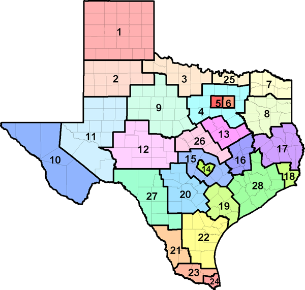
TEXAS COUNTY MAP BY WORKFORCE DEVELOPMENT AREA
* Due to confidentiality rules, not all regions may have the data displayed. The sum of all the regions may not be equal to the state total.


Top 10 Relevant Knowledge Areas Relevant Importance Levels
Geography
Knowledge of principles and methods for describing the features of land, sea, and air masses, including their physical characteristics, locations, interrelationships, and distribution of plant, animal, and human life.
94.20%
Computers and Electronics
Knowledge of circuit boards, processors, chips, electronic equipment, and computer hardware and software, including applications and programming.
89.60%
English Language
Knowledge of the structure and content of the English language including the meaning and spelling of words, rules of composition, and grammar.
80.80%
Mathematics
Knowledge of arithmetic, algebra, geometry, calculus, statistics, and their applications.
77.60%
Design
Knowledge of design techniques, tools, and principles involved in production of precision technical plans, blueprints, drawings, and models.
68.00%
Customer and Personal Service
Knowledge of principles and processes for providing customer and personal services. This includes customer needs assessment, meeting quality standards for services, and evaluation of customer satisfaction.
63.00%
Engineering and Technology
Knowledge of the practical application of engineering science and technology. This includes applying principles, techniques, procedures, and equipment to the design and production of various goods and services.
62.00%
Education and Training
Knowledge of principles and methods for curriculum and training design, teaching and instruction for individuals and groups, and the measurement of training effects.
60.80%
Administration and Management
Knowledge of business and management principles involved in strategic planning, resource allocation, human resources modeling, leadership technique, production methods, and coordination of people and resources.
57.60%
Administrative
Knowledge of administrative and office procedures and systems such as word processing, managing files and records, stenography and transcription, designing forms, and workplace terminology.
52.40%


Top 10 Relevant Skill Areas Relevant Importance Levels
Reading Comprehension
Understanding written sentences and paragraphs in work-related documents.
77.60%
Critical Thinking
Using logic and reasoning to identify the strengths and weaknesses of alternative solutions, conclusions, or approaches to problems.
72.40%
Active Listening
Giving full attention to what other people are saying, taking time to understand the points being made, asking questions as appropriate, and not interrupting at inappropriate times.
70.00%
Speaking
Talking to others to convey information effectively.
70.00%
Complex Problem Solving
Identifying complex problems and reviewing related information to develop and evaluate options and implement solutions.
65.00%
Judgment and Decision Making
Considering the relative costs and benefits of potential actions to choose the most appropriate one.
65.00%
Writing
Communicating effectively in writing as appropriate for the needs of the audience.
62.40%
Mathematics
Using mathematics to solve problems.
60.00%
Monitoring
Monitoring/Assessing performance of yourself, other individuals, or organizations to make improvements or take corrective action.
60.00%
Social Perceptiveness
Being aware of others' reactions and understanding why they react as they do.
60.00%


Top 10 Relevant Abilities Relevant Importance Levels
Deductive Reasoning
The ability to apply general rules to specific problems to produce answers that make sense.
75.00%
Oral Comprehension
The ability to listen to and understand information and ideas presented through spoken words and sentences.
75.00%
Written Comprehension
The ability to read and understand information and ideas presented in writing.
75.00%
Inductive Reasoning
The ability to combine pieces of information to form general rules or conclusions (includes finding a relationship among seemingly unrelated events).
72.40%
Information Ordering
The ability to arrange things or actions in a certain order or pattern according to a specific rule or set of rules (e.g., patterns of numbers, letters, words, pictures, mathematical operations).
72.40%
Near Vision
The ability to see details at close range (within a few feet of the observer).
72.40%
Problem Sensitivity
The ability to tell when something is wrong or is likely to go wrong. It does not involve solving the problem, only recognizing that there is a problem.
70.00%
Oral Expression
The ability to communicate information and ideas in speaking so others will understand.
70.00%
Visualization
The ability to imagine how something will look after it is moved around or when its parts are moved or rearranged.
67.60%
Speech Recognition
The ability to identify and understand the speech of another person.
67.60%


  • Working with Computers
    -- Using computers and computer systems (including hardware and software) to program, write software, set up functions, enter data, or process information.
  • Analyzing Data or Information
    -- Identifying the underlying principles, reasons, or facts of information by breaking down information or data into separate parts.
  • Processing Information
    -- Compiling, coding, categorizing, calculating, tabulating, auditing, or verifying information or data.
  • Getting Information
    -- Observing, receiving, and otherwise obtaining information from all relevant sources.
  • Updating and Using Relevant Knowledge
    -- Keeping up-to-date technically and applying new knowledge to your job.
Other Activities


  • Achievement
    - Occupations that satisfy this work value are results oriented and allow employees to use their strongest abilities, giving them a feeling of accomplishment. Corresponding needs are Ability Utilization and Achievement.
  • Independence
    - Occupations that satisfy this work value allow employees to work on their own and make decisions. Corresponding needs are Creativity, Responsibility and Autonomy.


Tools

Computer servers: Computer servers;

Desktop computers: Desktop computers;

Digital cameras: Digital cameras;

Global positioning system GPS receiver: Global positioning system GPS receivers;

Laser fax machine: Laser facsimile machines;

Laser printers: Computer laser printers;

Mainframe computers: Mainframe computers;

Notebook computers: Laptop computers;

Personal computers: Personal computers;

Photocopiers: Photocopying equipment;

Plotter printers: Large-format plotters; Plotters;

Portable data input terminals: Portable data collectors;

Radarbased surveillance systems: Light detection and ranging LIDAR systems; Synthetic aperture radar SAR;

Scanners: Computer data input scanners; Digitizers;

Special purpose telephones: Multi-line telephone systems;


Technology

Analytical or scientific software: Agronomic modeling software; Coordinate geometry COGO software; ESRI ArcGIS ArcPy; ESRI ArcGIS Survey 123; Hydrological modeling software; Landmark Graphics GeoGraphix; SAS; The MathWorks MATLAB;

Application server software: Kubernetes; GitHub; Docker;

Business intelligence and data analysis software: Tableau;

Cloud-based data access and sharing software: Microsoft SharePoint;

Cloud-based management software: IBM WebSphere;

Computer aided design CAD software: Computer aided design and drafting software CADD; Autodesk AutoCAD; Autodesk Land Desktop; Bentley MicroStation;

Content workflow software: Atlassian JIRA;

Data base management system software: Microsoft SQL Server; Relational database management software; Relational database management system RDMS; Oracle PL/SQL; Teradata Database;

Data base reporting software: SAP BusinessObjects Crystal Reports;

Data base user interface and query software: ServiceNow; National Land Cover Database NLCD; Soil Survey Geographic SSURGO; State Soil Geographic STATSGO Database; Structured query language SQL; Transact-SQL; Amazon Web Services AWS software; ADO.NET; dBASE; Autodesk Topobase; Microsoft Access;

Development environment software: List processing language LISP; Formula translation/translator FORTRAN; Go; C; Adobe ActionScript; ArcGIS Web AppBuilder; Web application software; Software development tools; Software libraries; Microsoft Visual Basic; Microsoft Visual Basic for Applications VBA; Microsoft Visual Basic Scripting Edition VBScript; Microsoft Visual Studio; Microsoft Azure DevOps Services; Microsoft Azure software; Microsoft .NET Framework;

Document management software: Microsoft Office SharePoint Server MOSS; Adobe Acrobat;

Electronic mail software: Email software; Microsoft Outlook;

Enterprise application integration software: Enterprise application integration EAI software; Extensible markup language XML; Jenkins CI;

Enterprise resource planning ERP software: Management information systems MIS; Microsoft Dynamics; SAP software;

File versioning software: Git;

Geographic information system: Geographic information system GIS software; Geographic information system GIS systems; ESRI ArcIMS; ESRI ArcInfo; ESRI ArcPad; ESRI ArcSDE; ESRI ArcView; Google Earth Pro; ESRI ArcEditor; ESRI ArcGIS Geostatistical Analyst; ESRI ArcGIS software; ESRI ArcGIS Spatial Analyst; QGIS;

Graphics or photo imaging software: Adobe Creative Cloud software; Adobe Illustrator; Adobe Photoshop;

Internet browser software: Web browser software;

Map creation software: RockWare ArcMap; Trimble Pathfinder Office; CDA International Manifold System; ITT Visual Information Solutions ENVI; Leica Geosystems ERDAS IMAGINE;

Mobile location based services software: Global positioning system GPS software;

Object or component oriented development software: jQuery; C#; C++; TypeScript; Sun Microsystems Java; R; Oracle Java; Perl; Python;

Object oriented data base management software: PostgreSQL;

Office suite software: Microsoft Office software; Google Workspace software;

Operating system software: Job control language JCL; Linux; Apple iOS; Operating system software; Shell script; UNIX;

Presentation software: Microsoft PowerPoint;

Process mapping and design software: Microsoft Visio;

Requirements analysis and system architecture software: Unified modeling language UML;

Spreadsheet software: Microsoft Excel;

Video creation and editing software: Adobe After Effects;

Web page creation and editing software: Adobe Dreamweaver;

Web platform development software: Bootstrap; Autodesk MapGuide; Cascading style sheets CSS; Drupal; LAMP Stack; Microsoft ASP.NET; JavaScript; JavaScript Object Notation JSON; Hypertext markup language HTML; Google Angular; Ext JS; Node.js; React; RESTful API; Oracle JavaServer Pages JSP; PHP;

Word processing software: Microsoft Word; Microsoft OneNote;


Related O*NET occupational titles for Geographic Information Systems Technologists and Technicians include:
  • 15-2099.01 Bioinformatics Technicians
  • 17-1021.00 Cartographers and Photogrammetrists
  • 15-1211.00 Computer Systems Analysts
  • 15-2051.00 Data Scientists
  • 15-1243.00 Database Architects
  • 17-1022.01 Geodetic Surveyors
  • 19-3092.00 Geographers
  • 19-2099.01 Remote Sensing Scientists and Technologists
  • 15-1252.00 Software Developers
  • 17-3031.00 Surveying and Mapping Technicians


No sources of additional information found.

Contact Texas Workforce Commission
Labor Market and Career Information  |  101 E. 15th Street, Annex Room 0252  |  Austin, Texas 78778
Official Website  |  1-800-822-PLAN (7526)  |  512.936.3200

** The information in this report may be derived from many sources like O*NET, BLS (Bureau of Labor Statistics), OOH (Occupational Outlook Handbook), and Career One Stop.